Geometric Calibration of Viking Lander EDR Images

Edward A. Guinness
Department of Earth and Planetary Sciences
McDonnell Center for the Space Sciences
Washington University
St. Louis, Missouri 63130


Table of Contents

  1. Introduction
  2. Lander Locations
  3. Lander Orientations
  4. Coordinate Systems and Camera Locations
  5. Camera Coordinate Transformations
  6. Stereo Measurements
  7. Figures
  8. References


1. Introduction

This document contains a description of the geometric properties of the Viking Lander cameras. Figures associated with this document are located in the GEOM directory and are stored in GIF format. The topics covered in this document include: A) Lander locations; B) Lander orientations; C) Coordinate systems and camera locations; D) Camera coordinate system transformations; and E) Stereo-ranging measurements.

A complete description of the Viking Lander camera system is found in the VOLINFO.TXT file located in the DOCUMENT directory. The Viking Lander cameras are facsimile scanning systems with each lander having two identical cameras. Looking from a lander toward the front, the camera to the left hand side is camera 1 and the camera to the right hand side is camera 2 (Figure 1). Each camera has a mirror that rotates about a horizontal axis by about 100 degrees in the elevation direction. Light enters the camera through 1 or 2 windows and is reflected off the mirror and onto the photosensor array. The entire camera assembly also rotates about a vertical axis to scan nearly 360 degrees in the azimuth direction. In acquiring an image, the camera first moves to the commanded starting azimuth position. The mirror rotates in 512 steps in elevation to scan a vertical line of the image. In-between each scan line, the camera moves a step in azimuth to build up the image. The process repeats until the commanded stop azimuth is reached. A detailed discussion of how the actual cameras are different from this simple, idealized system is found in Wolf [1981]. Such differences include, for example, the elevation rotation axis being behind the mirror and offset from the azimuth rotation axis; diffraction of light rays passing through the windows; and photodiodes being offset from the optical axis.


2. Lander Locations

The locations of the two Viking landers on Mars are given in the table below. Values are given in planetographic coordinates [Kieffer et al., 1992; Michael, 1979].

Lander Latitude Longitude
1 22.480 deg N 47.968 deg W
2 47.967 deg N 225.737 deg W


3. Lander Orientations

The orientations of the landers with respect to the local gravity vector and the direction of north are needed for planning, the preparation of topographic maps, and establishing viewing conditions in the scene at various times of the sol (Mars day) and season. Lander direction is defined as the compass direction of the line perpendicular to the intercamera baseline (perpendicular to front of lander). This direction can be thought of as looking straight out in front of the lander. The lander directions are 141.91 deg east of north for Lander 1 [Tucker, 1978; Mutch et al., 1976a] and 29.13 deg east of north for Lander 2 [Mutch et al., 1976b]. Each lander is also tilted relative to a local horizontal surface. Tilt is defined by a magnitude and direction. Lander 1 is tilted 2.99 deg downward in the direction of 285.17 deg east of north [Mutch et al., 1976a]. Lander 2 is tilted 8.2 deg downward in the direction of 277.7 deg east of north [Mutch et al., 1976b]. One effect of the tilt is that the horizon seen in EDR images is a sine wave pattern, which is much more noticeable in Lander 2 images because of the larger tilt magnitude. Figure 1 has schematic diagrams of the two landers showing the orientations and directions of tilt.

Summary of Lander Orientation
Lander Front Direction Tilt Magnitude Tilt Direction
1 141.91 deg 2.99 deg 285.17 deg
2 29.13 deg 8.2 deg 277.7 deg


4. Coordinate Systems and Camera Locations

Several coordinate systems are associated with the Viking Landers and cameras. In this section, four coordinate systems are described; two are centered on the cameras and two are centered on the landers. The next section describes how to convert from a given coordinate system to another. Several coordinate systems are in use to serve specific functions. For example, the Camera Aligned Camera Coordinate System (CACCS) is used for camera commands and the Lander Aligned Coordinate System (LACS) is used for the locations of lander components. There are additional lander coordinate systems that are not described here, such as the Lander Science Coordinate System and the Sampler Aligned Coordinate System. See Moore et al. [1987] for a description of these other coordinate systems.

a. Image Coordinates

In this document, image coordinates are defined as lines and samples. The line coordinate is aligned with camera elevation, whereas the sample coordinate is aligned with camera azimuth. Lines start with a value of 1 at the top of the image and increase toward the bottom. Viking Lander EDR images always have 512 lines. Samples begin with a value of 1 at the left side of the image and increase toward the right. Because the Viking Lander cameras could be commanded to scan from a minimum of 2.5 degrees to a maximum of about 340 degrees in azimuth, the number of samples can vary from one Viking Lander image to another.

b. Camera Aligned Camera Coordinate System

The coordinate system used to command the start and stop azimuths and center elevation of images was the Camera Aligned Camera Coordinate System (CACCS). Values of elevation and azimuth in the PDS labels and index files of this archive are also given in the CACCS. This coordinate system is a spherical system that is unique to each camera [Tucker, 1978].

The origin of the CACCS is the nominal intersection of the elevation and azimuth axes of a given camera (Figure 2). The elevation reference direction (0 deg elevation) in the CACCS is a plane containing the CACCS origin and perpendicular to the camera azimuth rotation axis. Positive values of elevation generally point toward the sky, whereas negative values generally point toward the ground. The azimuth reference direction (0 deg azimuth) is unique for each camera. For camera 1, the azimuth reference direction points toward camera 2 and is nominally at 9.5 degrees clockwise from the intercamera baseline when viewed from above. The intercamera baseline is the line connecting the origins of the CACCS of each camera. For camera 2, the azimuth reference direction is generally toward camera 1 and is nominally at 5.5 degrees clockwise from the intercamera baseline. In other words, the azimuth reference for camera 1 points slightly behind camera 2, whereas for camera 2 it points slightly in front of camera 1 (Figure 2). Differences from these nominal values are known as bolt-down errors, which are listed in the next section. Azimuths for both cameras increase in a clockwise direction.

c. Lander Aligned Camera Coordinate System

A second spherical coordinate system centered on each camera is the Lander Aligned Camera Coordinate System (LACCS). This system is used on some mission produced photoproducts and catalogs. The LACCS is similar to the CACCS in that both have the same origin and elevation definition. The difference in the two systems is in the azimuth reference direction. In the LACCS the azimuth reference direction for both cameras is perpendicular to the intercamera baseline and points toward the back of the lander. Azimuths increase in a clockwise direction when viewed from above (Figure 2) [Tucker, 1978].

d. Lander Aligned Coordinate System

The Lander Aligned Coordinate System (LACS) was a coordinate system used for some engineering aspects of the landers. The LACS is a Cartesian system, defined relative to the lander (Figure 3). However, the origin of the LACS is outside the lander and below the surface [Liebes, 1982]. The Z-Y plane of the LACS is parallel to the upper deck of the lander, but lies about 1.1 m below the upper deck (Figure 3). Note that both landers are tilted, so that the Y-Z plane is not necessarily parallel to the ground surface. The Z-X plane is perpendicular to the upper deck of the lander body and passes through the center of the upper deck and midway between the two cameras. The Y-X plane passes through the center of the lander upper deck and is perpendicular to the Z-Y and Z-X planes. The Z-axis is formed by the intersection of the Z-Y and Z-X planes and is positive toward the front of the lander. The X-axis is formed by the intersection of the Y-X and Z-X planes and is positive downward. The Y-axis is formed by the intersection of the Y-X and Z-Y planes and is positive to the left. Thus, the LACS is a right- handed coordinate system. The LACS origin is defined relative to the geometric center of the lander deck with the center point of the lander deck being along the -X axis and about 1.1 m above the origin [Moore et al., 1987]. As stated earlier, this means that the origin of the LACS is located below the surface of the nominal landing plane (Figure 3).

e. Local Mars System

The Local Mars System (LMS) is a Cartesian system that takes Lander orientation and tilt into account. The origin of the LMS is the same as the LACS. The +Z axis in the LMS is parallel with the local zenith vector (i.e., parallel to the local gravity normal vector). The +Y axis is pointed toward the north and the +X axis is pointed toward the east [Liebes, 1982].

f. Camera Locations

Camera locations are defined here as the locations of the CACCS and LACCS origins (i.e., the intersection of the camera elevation and azimuth rotation axes). The coordinates listed below are given in LACS coordinates. These values are nominal values. Wolf [1981] discusses deviations from these nominal values.

Camera 1 Camera 2
X -1.583 m -1.583 m
Y 0.411 m -0.411 m
Z 0.472 m 0.472 m

Given these values, the length of the intercamera baseline is the difference in Y coordinates of the two cameras, or nominally 0.822 m. The origins of the CACCS and LACCS are 0.487 m above the lander deck and about 1.3 m above a nominal horizontal landing plane (Figure 3) [Liebes, 1982].


5. Camera Coordinate Transformations

This section details how to convert from one relevant Viking Lander imaging coordinate system to another. Note that computing coordinates of points in the LACS requires stereo imaging, which is discussed in the next section.

a. Image Coordinates to CACCS

The computation of CACCS azimuth and elevation from image coordinates is a straightforward linear scaling with several additional terms for camera errors and other effects. In most cases, CACCS elevation (El) is computed as:

El = Elc + S * (256.5 - ln) + Be (1)

where Elc is the image center elevation, S is the image sampling rate (either 0.04 or 0.12 degrees/pixel), ln is the image line number of the point, and Be is the elevation bolt-down correction. The center elevation and sampling rate (as sampling_parameter_interval) are found in the PDS image label and index file of this archive. The bolt-down term in equation 1 corrects for the effect of the camera not being mounted in a true vertical position. Values of Be are constants unique to each camera. Values of Be in degrees are listed in the table below and are from an unpublished Lander Imaging Team memo.

Elevation Bolt-Down Values
Lander 1 Lander 2
camera 1 -0.18 -0.08
camera 2 -0.07 -0.17

Several Viking Lander images were acquired where the diode and sampling rate did not match in resolution, e.g., high resolution color images. In such cases an additional term (D) is needed in equation 1 due to the camera electronics:

El = Elc + S * (256.5 -ln) + Be + D (2)

where D is -5.6 deg if the sampling rate was 0.04 deg and the diode was one of blue, green, red, IR1, IR2, IR3, survey, or sun. The value of D is +5.6 deg if the sampling rate was 0.12 deg and the diode was one of BB1, BB2, BB3, or BB4. In other words, the image is shifted down in elevation for high resolution sampling with a low resolution diode and shifted up in elevation for low resolution sampling with a high resolution diode.

CACCS azimuth (Az) is computed from image sample number by:

Az = Azs + S * (sm - 1) + Ba + C (3)

where Azs is the start azimuth, S is the sampling rate, sm is the image sample number of the point, Ba is the azimuth bolt-down correction, and C is the coning angle correction. Again start azimuth and sampling rate are found in the PDS image label or the index file of this archive. The azimuth bolt-down correction compensates for the difference in the actual and nominal azimuth reference direction. The values of Ba are given below in degrees and are from an unpublished Lander Imaging Team memo.

Azimuth Bolt-Down Values
Lander 1 Lander 2
camera 1 -0.79 -0.87
camera 2 -0.20 -0.10

The coning angle correction is due to the diodes being offset from the optical axis by +/- 0.48 degrees. This effect causes the scan lines to scribe curved lines in the scene instead of straight lines. The magnitude of the coning error is a function of elevation and the sign depends on which side of the photosensor array the diode is on. The coning correction is computed as:

C = +/- arctan (tan(a)/cos(El)) - a (4)

where a is 0.48 degrees and El is the elevation angle. The sign is positive for diodes BB2, BB4, blue, green, red, and sun; and negative for diodes BB1, BB3, IR1, IR2, IR3, and survey.

b. CACCS to LACCS

The conversion from CACCS to LACCS is a simple change in the azimuth reference direction (0 deg azimuth). Elevation values in CACCS and LACCS are the same. The conversion for camera 1 is:

Azl = Azc - 80.5 (5)

where Azl is azimuth in LACCS and Azc is azimuth in CACCS. Likewise, the conversion for camera 2 is:

Azl = Azc + 95.5 (6)

All values of azimuth are in degrees.

c. LACCS to LACS

Using the definitions of the LACCS (or CACCS) provides only the direction to a point in the scene. To convert to LACS coordinates, the range to the point is needed along with the direction. Both direction and range can only be determined from stereo images (i.e., viewing the same point with two cameras separated by some distance). Methods for determining true direction and range to points are discussed in the next section.

Crude estimates of range to a point can be made from a single image by assuming the surface is a horizontal plane 1.3 m below the cameras (Figure 3). Such estimates are useful for areas of the lander site that can only be viewed by one camera, i.e., areas to either side of the landers, like the large boulder named Big Joe. An estimate of slant range (R) between the camera and a point in the scene is computed using a right triangle as:

R = 1.3 / sin(El) (7)

where El is the camera elevation of the point and R is in meters. An estimate of the horizontal distance (H) from the camera to the point is:

H = 1.3 / tan(El) (8)

The size of an object (Sz) can also be approximated from a single image from its angular size (i.e., difference in azimuth at constant elevation) as:

Sz = Da * R (9)

where Da is the difference in azimuth in radians and R is the slant range from the camera (from equation 7).

d. LACS to LMS

The conversion from LACS to LMS removes lander tilt and aligns the axes with north and east. The transformation involves a matrix rotation that is unique to each lander:

[Vm] = [Rm] * [Vl] (10)

where [Vm] is a three element vector of LMS x, y, and z coordinates, [Rm] is a 3x3 rotation matrix, and [Vl] is a three element vector of LACS x, y, and z coordinates. The elements of [Rm] for the two Viking landers are given in the tables below [Liebes, 1982].

[Rm] for Lander 1
0.0503457 0.7858010 0.6164240
-0.0136545 0.6176890 -0.7862990
-0.9986370 0.0311701 0.0418279

[Rm] for Lander 2
0.1414660 -0.8623340 0.4861690
-0.0191174 0.4886360 0.8722730
-0.9897580 -0.1326930 0.0526407


6. Stereo Measurements

Viking Lander stereo imaging techniques can measure the position of a point by using azimuth and elevation pointing information from both cameras. Because of the camera separation, a point in the scene is viewed by each camera with a different perspective. The direction from each camera to the point defines two vectors, with the intersection of the vectors giving the 3-dimensional position of the point. Stereo measurements are largely confined to areas in front of the landers due to limits in the azimuth range and due to obscuration by lander parts. Some areas behind the landers can be seen stereoscopically.

During the Viking Mission a custom hardware and software system existed for stereo analysis mainly to support mission activities, such as collecting samples [Liebes and Schwartz, 1977]. This system included real-time stereo viewing and ray-trace algorithms for geometric correction of non-ideal imaging system effects [Wolf, 1981]. Accurate ranging measurements can still be made by a less sophisticated method of simply measuring image coordinates of a point in both camera 1 and 2 images and computing the LACS coordinates using the equations listed below [Moore et al., 1987]. This simple method works best with pairs of images acquired with the same diode and with similar lighting conditions so that features look similar in both images. However, the equations given below will give reasonable solutions for any diode combination. Also, there is evidence that Viking Lander 2 moved a small amount during the mission, so using images acquired close in time will eliminate errors due to lander movement [Moore et al., 1987]. Ranging errors increase rapidly with distance from the lander, when the azimuth of the two cameras are similar, and when the azimuths approach the direction of the intercamera baseline [Liebes, 1982; Liebes and Schwartz, 1977].

Figure 4 shows the geometry of the vectors and angles used to derive the ranging equations. For convenience, LACCS azimuths are adjusted by subtracting 90 degrees:

Camera 1: A = Az2 - 90 (11)
Camera 2: B = Az1 - 90 (12)

where Az1 and Az2 are the LACCS azimuths for camera 1 and 2, respectively. These new angles (A and B) are relative to the +Y axis of the LACS. The equations used to compute the coordinates of a point in LACS are:

f = I * sin(A) / sin(B-A) (13)
x = -f * tan(E1) - 1.583 (14)
y = f * cos(B) + 0.411 (15)
z = f * sin(B) + 0.472 (16)

where f is the horizontal distance between camera 1 and the point, I is the intercamera baseline length (0.822 m), E1 is the camera 1 elevation angle of the point, and x, y, and z are LACS coordinates in meters.


7. Figures

Figure 1: Diagram showing the lander orientation and tilt directions, along with the relative locations of the two cameras. The dashed line between the cameras represents the intercamera baseline. After Tucker [1978].


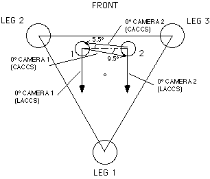
Figure 2: Schematic showing the azimuth reference directions (0 deg. azimuth) for the CACCS and LACCS. After Tucker [1978].


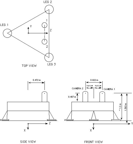
Figure 3: Schematic showing the origin and orientation of axes for the LACS. The diagram also shows the position of the cameras relative to the LACS origin. Diagram is not to scale. After Liebes [1982].


Figure 4: Schematic showing the vectors and angles used to derive the equations for stereo ranging to point P. The Y and Z axes are for the LACS. The side view is a plane parallel to the LACS X axis and intersects both camera 1 and the point P.


8. References

Kieffer, H. H., B. M. Jakosky, and C. W. Snyder, The planet Mars: From antiquity to the present, in Mars, Kieffer et al., eds., University of Arizona Press, Tucson, 1992.

Liebes, S., Viking Lander Atlas of Mars, NASA Contractor Report 3568, 1982.

Liebes, S., and A. A. Schwartz, Viking 1975 Mars lander interactive computerized video stereophotogrammetry, J. Geophys, Res., 82, 4421-4429, 1977.

Michael, W. H., Viking Lander tracking contributions to Mars mapping, Moons and Planets, 20, 149-152, 1979.

Moore, H. J., R. E. Hutton, G. D. Clow, and C. R. Spitzer, Physical properties of the surface materials at the Viking landing sites on Mars, USGS Professional Paper 1389, 1987.

Mutch, T. A., A. B. Binder, F. O. Huck, E. C. Levinthal, S. Liebes, E. C. Morris, W. R. Patterson, J. B. Pollack, C. Sagan, and G. R. Taylor, The surface of Mars: The view from the Viking 1 Lander, Science, 193, 791-800, 1976a.

Mutch, T. A, S. U. Grenander, K. L. Jones, W. Patterson, R. E. Arvidson, E. A. Guinness, P. Avrin, C. E. Carlston, A. B. Binder, C. Sagan, E. W. Dunham, P. L. Fox, D. C. Pieri, F. O. Huck, C. W. Rowland, G. R. Taylor, S. D. Wall, R. Kahn, E. C. Levinthal, S. Liebes, R. B. Tucker, E. C. Morris, J. B. Pollack, R. S. Saunders, and M. R. Wolf, The surface of Mars: The view from the Viking 2 Lander, Science, 194, 1277- 1283. 1976b.

Tucker, R. B., Viking Lander imaging investigation: Picture catalog of primary mission experiment data record, NASA Reference Publication 1007, 1978.

Wolf, M. R., Viking lander camera geometry calibration report, NASA JPL Pub. 79-54, 1981.