
September 1998
Version 1.5
JPL
Jet Propulsion Laboratory
4800 Oak Grove Drive
Pasadena, California 91109-8099
1.1 Product and Transferal Mechanism
2.1 Structure and Organization Overview
| 1.1 | VICAR Software for Mars Pathfinder Rover Image Data Files |
| BTC | Block Truncation Coding |
| CAHV | Camera model described by four vectors C, A, H and V |
| CAHVOR | Camera model CAHV with CCD and non-linear distortions accounted |
| CCD | Charge-Coupled Device |
| EDR | Experiment Data Record |
| IMP | Imager for Mars Pathfinder |
| MIPS | Multimission Image Processing Subsystem |
| PDS | Planetary Data System |
| TBD | To Be Determined |
| URL | Universal Resource Locator |
| VICAR | Video Image Communication and Retrieval system |
| Item | Pages | Assignee | Closure Date |
| none |
The single frame form is an image of maximum dimensions 492 lines by 768 samples. Because the Rover camera CCD has a photosensitive area of 484 rows by 768 samples, a majority of full-frame images will be 484 lines by 768 samples. The color, band-sequential form is an ordered set of red, green, and blue image bands, each band with a maximum dimension of 768 lines by 492 samples. The VICAR software used to generate these image products is described in Table 1.1.
| Application | Description |
| MPFTELEMPROC | Fetches the image Standard Formatted Data Unit (SFDU) records from the Telemetry Delivery Subsystem (TDS), and reconstructs the image file from the telemetry data. This application produces a VICAR image file with a subset of descriptive label items. It also accesses the catalog (or SPICE kernels) to supplement the ancillary image information from the telemetry data. Note that the rear camera images are rotated 90 degrees within MPFTELEMPROC such that output image data has its vertical dimension along the image's line dimension, just as the front cameras do. |
| MPFCAHV | Converts uncorrected images to a corrected CAHV camera model. |
| MPFPDSLBL | Converts the VICAR EDR into a PDS complient labelled image file. |
| MPFRVRCLR | Generates color image from the Rover's rear camera. |
| MPFRVRMOS | Mosacis multiple rover frames from one image. It has rudimentary dark current and exposure correction capability |
The labels (VICAR) are potentially split into two parts, one at the beginning of the file, and one at the end. Normally, only the labels at the front of the file will be present. However, of the EOL keyword in the system label (described below) is equal to 1, then the EOL labels (End Of file Labels) are present. This happens if the labels expand beyond the space allocated for them. The VICAR file is treated as a series of fixed-length records, of size RECSIZE (see below). The image area always starts at a record boundary, so there may be unused space at the end of the label, before the actual image data starts.The label consists of a sequence of "keyword=value" pairs that describe the image (or data file), and is made up entirely of ASCII characters. Each keyword-value pair is separated by spaces. Keywords are strings, up to 32 characters in length, and consist of uppercase characters, underscores (_), and numbers (but should start with a letter). Values may be integer, real, or strings, and may be multiple (e.g. an array of 5 integers, but types cannot be mixed in a single value). Spaces may appear on either side of the equals character (=), but are not normally present.
The first keyword is always LBLSIZE, which specifies the size of the label area in bytes. LBLSIZE is always a multiple of RECSIZE, even if the labels don't fill up the record. If the labels end before LBLSIZE is reached (the normal case), then a 0 byte terminates the label string. If the labels are exactly LBLSIZE bytes long, a null terminator is not necessarily present. The size of the label string is determined by the occurrence of the first 0 byte, or LBLSIZE bytes, whichever is smaller.
If the system keyword EOL has the value 1, then End-Of-file Labels exist at the end of the image area (see above). The EOL labels, if present, start with another LBLSIZE keyword, which is treated exactly the same as the main LBLSIZE keyword. The length of the EOL labels is the smaller of the length to the first 0 byte or the EOL's LBLSIZE. Note that the main LBLSIZE does not include the size of the EOL labels. In order to read in the full label string, simply read in the EOL labels, strip off the LBLSIZE keyword, and append the rest to the end of the main label string.
In Figure 2.1, NL is the number of image lines; NS is the number of image samples per line; and NB is the number of image bands. LBLSIZE is the total number of bytes within the VICAR label, and RECSIZE is the total number of bytes per file record.
The nominal Rover image frame size is 484 lines by 768 samples for monchrome images and 768 lines by 484 samples for band-sequential color images, but may be smaller based on commanded image size. The image data format is unsigned character (8-bit pixels).
The VICAR header or label is a part of this image file. This label is organized in an ASCII, keyword-equals-value format and contains information regarding the observation which produced the spectrum data. This observation information includes general descriptors such as target and time tags of the start of image acquisition, camera and spacecraft state parameters, data compression information, viewing and lighting geometry, spacecraft position and camera pointing, image dimensions, and processing history. See Figure 2.2 for the label keywords to be included in the VICAR label. The figure shows a template that describes the displayed format of this VICAR label. All keywords are described in detail in the Appendix. Note that delivered images may have keywords listed in a slightly different order than what is shown here.
        ************  File r<sclk>.img_<command_sequence_number> ************
	3 dimensional IMAGE file
	File organization is BSQ
	Pixels are in BYTE format from a <host type> host
	1 bands
	<nnn> lines per band
	<nnn> samples per line
	0 lines of binary header
	0 bytes of binary prefix per line

---- Property: CAMERA_MODEL ----
AZIMUTH_FOV = 2.2
ELEVATION_FOV = 1.6
FOCAL_CENTER_VECTOR = <array of 3 floating point numbers>
HORIZONTAL_IMAGE_PLANE_VECTOR = <array of 3 floating point numbers>
POINTING_DIRECTION_VECTOR = <array of 3 floating point numbers>
VERTICAL_IMAGE_PLANE_VECTOR = <array of 3 floating point numbers>

---- Property: DECOMPRESSION ----
INST_CMPRS_BLK_SIZE = (4, 16)
INST_CMPRS_BLOCKS = nnnn
INST_CMPRS_NAME = 'BTC'
INST_CMPRS_RATE = 0.6125
INST_CMPRS_RATIO = 4.9

---- Property: OBSERVATION ----
APPLICATION_PACKET_ID = nn
COMMAND_SEQUENCE_NUMBER = nnnnn
EXPOSURE_DURATION = ffff.f
EXPOSURE_TYPE = 'AUTO', 'manual', 'guestimate' or 'NULL'
FIRST_LINE = nnn
FIRST_LINE_SAMPLE = nnn
FRAME_ID = <'LEFT', 'RIGHT' or 'REAR'>
IMAGE_ID = <APID code letter><command_sequence_number>
IMAGE_TIME = 'yyy-mm-ddThh:mm:ss.mmmZ'
INSTRUMENT_TEMPERATURE = ff.fff
LINEAR_ACCELEROMETER = (ff.ff, ff.ff)
MAXIMUM = nnn
MEAN = fff.ff
MEDIAN = nnn
MINIMUM = nnn
MPF_LOCAL_TIME = 'hh:mm:ss'
OBSERVATION_NAME = 'string describing type of observation'
PLANET_DAY_NUMBER = nn
ROVER_HEADING = nnnnn
ROVER_POSITION = (fff.fff, fff.fff)
SPACECRAFT_CLOCK_START_COUNT = nnnnnnnnnn
STANDARD_DEVIATION = ff.fff
TARGET_NAME = 'NULL'

---- Property: PDS ----
APPLICATION_PACKET_NAME = 'string describing purpose of observation '
BAND_SEQUENCE = 'N/A'
BAND_STORAGE_TYPE = 'N/A'
BANDS = 1
CHECKSUM = nnnnn
COMMAND_DESC = 'NULL'
DATA_SET_ID = 'MPFR-M-RVRCAM-2-EDR-V1.0'
DATA_SET_NAME = 'MARS PATHFINDER ROVER MARS ROVER CAMERA 2 EDR VERSION 1.0'
DETECTOR_PIXEL_HEIGHT = 13.6
DETECTOR_PIXEL_WIDTH = 11.6
INST_CMPRS_DESC = 'Raw-data; uncompressed' or 'Block Truncation Coding (BCT)'
INSTRUMENT_HOST_ID = 'MPFR'
INSTRUMENT_HOST_NAME = 'MICROROVER FLIGHT EXPERIMENT'
INTERCHANGE_FORMAT = 'BINARY'
LINES = nnn
LINE_SAMPLES = nnn
PDS_VERSION_ID = 'PDS3'
PROCESSING_HISTORY_TEXT =
'CODMAC Level 1 to Level 2 conversion via JPL/MIPL MPFTELEMPROC'
PRODUCER_FULL_NAME = 'Allan J. Runkle'
PRODUCER_INSTITUTION_NAME =
'Multimission Image processing Laboratory, Jet Propulsion Lab'
SAMPLE_BITS = 8
SAMPLE_BIT_MASK = '2#11111111#'
SAMPLE_TYPE = 'MSB_UNSIGNED_INTEGER'
SOLAR_AZIMUTH = fff.ff
SOLAR_ELEVATION = ff.ff

--- Property: TELEMPROC ----
EARTH_RECEIVED_START_TIME = 'yyy-mm-ddThh:mm:ss.mmmZ'
EARTH_RECEIVED_STOP_TIME = 'yyy-mm-ddThh:mm:ss.mmmZ'
EXPECTED_PACKETS = nnn
INSTRUMENT_ID = 'RVRC'
INSTRUMENT_NAME = 'ROVER CAMERA <LEFT , RIGHT or  REAR>'
MISSION_NAME = 'MARS PATHFINDER'
PRODUCER_ID = 'MIPL of JPL'
PRODUCT_CREATION_TIME = 'yyy-mm-ddThh:mm:ss.mmmZ'
PRODUCT_ID = 'RVR_EDR-<sclk>-<image_id>-<frame_id>'
RECEIVED_PACKETS = nn
SOFTWARE_NAME = 'MPFTELEMPROC_RVR'
SOFTWARE_VERSION_ID = 'Version of MIPL telemetry processing software used'
SOURCE_PRODUCT_ID = '<E Kernel filename>'
SPACECRAFT_NAME = 'MARS PATHFINDER ROVER'
TLM_CMD_DISCREPANCY_FLAG = <'TRUE' or 'FALSE'>

---- Task: TASK -- User: <username> -- <date and time for product creation> ----
The PDS label file is an object-oriented file; the object to which the label refers is denoted by a statement of the form:
^object = locationin which the carat character (^, also called a pointer in this context) indicates that the object starts at the given location. In a detached label, the location denotes the name of the file containing the object, along with the starting record or byte number, if there is more than one object. For example:
^IMAGE = 3indicates that the IMAGE object begins at record 3 of the file.
All labels contain 80-byte fixed-length records, with a carriage return character (ASCII 13) in the 79th byte and a line feed character (ASCII 10) in the 80th byte. This allows the files to be read by the HFS, MacOS, DOS, OS2, Unix, and VMS operating systems.
Figure 2.3 is a template of the Rover EDR PDS label. See the Appendix for detailed definitions and formatting information for the label items. Also note label item values that are capitalized or enclosed in quotes and not italicized represent label item values to be written verbatim.
PDS_VERSION_ID                 = PDS3

/* FILE CHARACTERISTICS */

RECORD_TYPE                    = FIXED_LENGTH
RECORD_BYTES                   = number of bytes per record in the file
FILE_RECORDS                   = total number of records in the file
LABEL_RECORDS                  = number of records in the file containing
                                 only label information

/* POINTERS TO DATA OBJECTS */

^IMAGE                         = first record in file containing image data

/* IDENTIFICATION DATA ELEMENTS */

DATA_SET_ID                    = "MPFR-M-RVRCAM-2-EDR-V1.0"
DATA_SET_NAME                  = "MARS PATHFINDER ROVER MARS ROVER CAMERA 2
                                  EDR VERSION 1.0"
PRODUCER_ID                    = "MIPL OF JPL"
PRODUCER_FULL_NAME             = "ALLAN J. RUNKLE"
PRODUCER_INSTITUTION_NAME      = "MULTIMISSION IMAGE PROCESSING LABORATORY,
                                  JET PROPULSION LAB"
PRODUCT_ID                     = "RVR_EDR-<sclkstrtcnt>-<image_id>-<frame_id>"
IMAGE_ID                       = "nnnnnnn"
FRAME_ID                       = <LEFT, REAR, RIGHT>
MISSION_NAME                   = "MARS PATHFINDER"
INSTRUMENT_HOST_NAME           = "MICROROVER FLIGHT EXPERIMENT"
INSTRUMENT_HOST_ALIAS_NAME     = {"MARS PATHFINDER ROVER", "SOJOURNER"}
INSTRUMENT_HOST_ID             = "MPFR"
INSTRUMENT_NAME                = "ROVER CAMERA RIGHT"
INSTRUMENT_ID                  = "RVRC"
IMAGE_TIME                     = yyyy-mm-ddThh:mm:ss.fffZ
PLANET_DAY_NUMBER              = nn
MPF_LOCAL_TIME                 = hh:mm:ss
SPACECRAFT_CLOCK_START_COUNT   = nnnnnnnnnn
EARTH_RECEIVED_START_TIME      = yyyy-mm-ddThh:mm:ss.fffZ
EARTH_RECEIVED_STOP_TIME       = yyyy-mm-ddThh:mm:ss.fffZ
PRODUCT_CREATION_TIME          = yyyy-mm-ddThh:mm:ss.fffZ

/* DESCRIPTIVE DATA ELEMENTS */

EXPECTED_PACKETS               = n
RECEIVED_PACKETS               = n
APPLICATION_PACKET_ID          = n
APPLICATION_PACKET_NAME        = group name associated with APID
OBSERVATION_NAME               = purpose of observation
EXPOSURE_DURATION              = f.ffff
EXPOSURE_TYPE                  = <AUTO, MANUAL, REUSE>
INSTRUMENT_TEMPERATURE         = f.ffff
DETECTOR_PIXEL_HEIGHT          = f.ffff
DETECTOR_PIXEL_WIDTH           = f.ffff
SOURCE_PRODUCT_ID              = standard SPICE kernel names for PCK, SPK, etc
SOFTWARE_NAME                  = name of MPF telemetry processing software
SOFTWARE_VERSION_ID            = version of MPF telemetry processing software
PROCESSING_HISTORY_TEXT        = "CODMAC LEVEL 1 TO LEVEL 2 CONVERSION VIA
                                  JPL/MIPL MPFTELEMPROC"

/* GEOMETRY DATA ELEMENTS */

ROVER_HEADING                  = n
ROVER_POSITION                 = (f.ffff, f.ffff)
LINEAR_ACCELEROMETER           = (f.ffff, f.ffff)
SOLAR_AZIMUTH                  = f.ffff
SOLAR_ELEVATION                = f.ffff
POSITIVE_ELEVATION_DIRECTION   = UP

/* ROVER FLIGHT SOFTWARE COMMAND DATA ELEMENTS */

COMMAND_SEQUENCE_NUMBER        = n
TLM_CMD_DISCREPANCY_FLAG       = <TRUE, FALSE>

/* COMPRESSION DATA ELEMENTS */

INST_CMPRS_BLOCKS              = n
INST_CMPRS_NAME                = onboard compression used for data
                                 storage and transmission
INST_CMPRS_DESC                = textual description of inst_cmprs_name

/* IMAGE OBJECT DATA ELEMENTS */

OBJECT                         = IMAGE
  INTERCHANGE_FORMAT           = BINARY
  LINES                        = n
  LINE_SAMPLES                 = n
  BANDS                        = 1
  BAND_SEQUENCE                = "N/A"
  BAND_STORAGE_TYPE            = "N/A"
  SAMPLE_TYPE                  = MSB_UNSIGNED_INTEGER
  SAMPLE_BITS                  = 8
  SAMPLE_BIT_MASK              = 2#11111111#
  MAXIMUM                      = n
  MEAN                         = f.ffff
  MEDIAN                       = n
  MINIMUM                      = n
  STANDARD_DEVIATION           = f.ffff
  FIRST_LINE                   = n
  FIRST_LINE_SAMPLE            = n
  CHECKSUM                     = <32 bit unsigned integer>
END_OBJECT                     = IMAGE
END
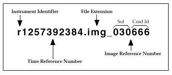
Instrument Identifier - The instrument identifier will always be the lowercase letter 'r', representing the rover.Time Reference Number - The time reference number will be the 10-digit Spacecraft Clock Start Count, as described in Appendix A.
File Extension - The file extension is a three character mnemonic that will always be used for data files. Monochrome and packed-color rear camera image files will have a file extension of "img," and unpacked rear camera image files (color image files) will have an extension of "rgb".
Image Reference Number - Finally, the image reference number is the Command Sequence Number appended onto the file extension.
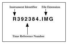
Instrument Identifier - The instrument identifier will always be the uppercase letter 'R'.
Time Reference Number - The time reference number will be the least significant 6-digits of the Spacecraft Clock Start Count (the 4 significant digits will be used as part of the directory hierarchy storing the image files).
File Extension - Finally, the file extension will be the same three character mnemonic, Monochrome and packed-color rear camera image files will have a file extension of "IMG," and unpacked rear camera image files (color image files) will have an extension of "RGB".
.IMG for single-band images from any Rover camera .RGB for band-sequential, color images from Rover rear camera
| Label Item | Description | Data Type (organization) |
Valid Values |
|---|---|---|---|
| APPLICATION_PACKET_ID | Classifies the telemetry packet from which the image data was obtained. This packet ID is handed to the Telemetry download. This value is based on a set of values specified in the Downlink Telemetry Documents (JPL). This acronym is APID. | integer | (see Mars Pathfinder Rover Telemetry Dictionary [3]) |
| AZIMUTH_FOV | The angular coverage of the entire imagimg area of the rover camera measured horizontally with respect to the image plane in spacecraft coordinates; units are radians. | floating point | 2.2 or 1.6 |
| COMMAND_SEQUENCE_NUMBER | Number from corresponding uplink command (zero for autonomously generated messages). | integer | <any positive value> |
| The command_sequence_number in the uplink command did
not have the range necessary to follow the convention of allocating
the least significant 3 digits for the image ID and the upper digits
for the Solar Day. To compensate, a synthetic command_sequence_
number was generated from the commanded value and the solar day of
execution. The resulting command_sequence_number is calculated as
follows: 50000 * (int)(planet_day_number / 50) + command_sequence_number |
|||
| EARTH_RECEIVED_START_TIME | Identifies the ealiest time a packet was received that conatained data for the image. | character array | YYYY-MM-DDThh:mm:ss.fffZ |
| EARTH_RECEIVED_STOP_TIME | Identifies the latest time a packet was received that conatained data for the image. | character array | YYYY-MM-DDThh:mm:ss.fffZ |
| ELEVATION_FOV | The angular coverage of the entire imagimg area of the rover camera measured vertically with respect to the image plane in spacecraft coordinates; units are radians. | floating point | 1.6 or 2.2 |
| EXPECTED_PACKETS | Total number of telemetry packets which constitute a complete image, an image without missing data. | integer | <any positive value> |
| EXPOSURE_DURATION | Integration time for CCD measured in milliseconds | integer | <any positive value> |
| EXPOSURE_TYPE | Defines the type of exposure used for this image | character (array) |
AUTO MANUAL REUSE |
| FIRST_LINE | Indicates the line within a source image that corresponds to the first line in a sub-image. | integer | [1,492] for front camera; [1,768] for rear camera. |
| FIRST_LINE_SAMPLE | Indicates the sample within a source image that corresponds to the first sample in a sub-image. | integer | [1,768] for front camera; [1,492] for rear camera. |
| FOCAL_CENTER_VECTOR | Position of the entrance pupil point of the camera lens (focal center) measured relative to the external coordinate system. Corresponds to the C vector in the CAHV camera model. | floating point (array of 3 elements) | N.A. |
| FRAME_ID | Provides an identification for a particular instrument measurement frame. | character (array) | LEFT, RIGHT, REAR |
| HORIZONTAL_IMAGE_PLANE_VECTOR | H = H' + xcA, where H' is a unit vector parallel to the x-axis in the camera's image plane, and xc is the point of intersection of a perpendicular dropped from the exit pupil point of the camera lens. H', A', V' are mutually orthogonal. Corresponds to the H vector in the CAHV camera model. | floating point (array of 3 elements) | N.A. |
| IMAGE_ID | Unambiguously identifies an image. IMAGE_ID is a concatenation of APID code letter, and command sequence number. Each APID code maps to a APID code letter to be used in the IMAGE_ID. The following is a mapping of number to uppercase letter: 8, 'S'; 9, 'T'; 10, 'L'; 24, 'A'; 25, 'N'. 'S' represents science; 'T' represents technology; 'L' represents Lander engineering; 'A' represents autonomous; and 'N' represents operations or navigation. A sample image id is "L09329," where this image is a Lander engineering image. The command sequence number is 09329. | character (array) of length 7 | N.A. |
| IMAGE_TIME | Time at which the image was acquired, recorded in UTC format. | character (array) | YYYY-MM-DDThh:mm:ss.ffffZ |
| INST_CMPRS_BLK_SIZE | Dimension of a block for compression; line dimension of the block is the first element, followed by the sample dimension of the block. | integer (array) | (4,4) |
| INST_CMPRS_BLOCKS | Number of blocks used to spatially segment the image file prior to compression. | integer | <any positive value that is the image number of pixels divided by the block area> |
| INST_CMPRS_NAME | The type of compression or encryption used for data storage. Contents of this value should be the full, unabbreviated, non-acronym name of coding or compression type. Examples of encoding types include but are not limited to Integer Cosine Transform (ICT), Block Truncation Coding (BTC), Discrete Cosine Transform (DCT), Joint Photographic Experts Group (JPEG) Standard DCT. | character (array) | "BTC" (Block Truncation Coding) |
| INST_CMPRS_RATE | Average number of bits needed to represent a pixel with a compressed image. | floating point | 0.6125 |
| INST_CMPRS_RATIO | Ratio in bytes of the original, uncompressed data file length to its compressed form. For example, a compression ratio of 5.00 means that on average, for every five bytes of input data, one byte of compressed data was generated. | floating point | 4.9 |
| INSTRUMENT_ID | Acronym of the instrument name | character (array) | RVRC |
| INSTRUMENT_NAME | Full name of an instrument. | character (array) | "ROVER CAMERA LEFT" or "ROVER CAMERA RIGHT" or "ROVER CAMERA REAR" |
| INSTRUMENT_TEMPERATURE | The temperature of the sensor (CCD) array when the image was acquired, measured in degrees Celsius. | floating point | N.A. |
| LINEAR_ACCELEROMETER | X and Y readings for linear accelerometers on the Rover spacecraft. X indicates pitch, where positive values indicate Rover front is lower; Y indicates roll, where positive values indicating right side is lower. Values are in units of g where 1 g equals 9.8 m/sec**2. Thus, raw readings from telemetry are multiplied by 0.0009765 g, | floating point (array of two elements) | N.A. |
| MAXIMUM | The maximum Dn value in the image file, between the Rover CCD valid range (0 to 255). | integer | [0, 255] |
| MEAN | The mean pixel value for the pixels within the valid Dn range. | floating point | [0.0, 255.0] |
| MEDIAN | The median pixel value for the pixels within the valid Dn range. | integer | [0, 255] |
| MINIMUM | The minimum Dn value in the image file, between the Rover CCD valid range (0 to 255). | integer | [0, 255] |
| MISSION_NAME | A major planetary mission or project. | character (array) | "MARS PATHFINDER" |
| MPF_LOCAL_TIME | Reference time based on the IAU standard for the Martian prime meridian. For detailed description, see the Report of the IAU/IAG/COSPAR Working Group on Cartographic Coordinates and Rotational Elements of the Planets and Satellites: 1991. | character (array) | hh:mm:ss.fff |
| OBSERVATION_NAME | Identifies the name of the type of observsation for which this image was taken. This value os obtained from the Rover e-kernel. | character (array) | N.A. |
| PLANET_DAY_NUMBER | The martian day on which the image was packetized. This is a counter that starts with '1' as the first day of surface operations. '0' refers to a pre surface operations image. | integer | <any positive number> |
| POINTING_DIRECTION_VECTOR | A unit vector A in the direction in which the first (or second) camera is pointed; the direction of the symmetry axis of the camera lens as measured in the external coordinate system. Corresponds to the A vector in the CAHV camera model. | floating point (array of 3 elements) | N.A. |
| PRODUCER_ID | Short name or acronym for the producer or producing team/group of a dataset. | character (array) | "MIPS of JPL" |
| PRODUCT_CREATION_TIME | Defines the UTC time when a product was created. | time | YYYY-MM-DDThh:mm:ss.fffZ |
| PRODUCT_ID | A permanent, unique identifier assigned to a data product by its producer. | character (array) | "RVR_EDR-<sclk_start_count>-<image_id>-<frame_id>" |
| RECEIVED_PACKETS | Total number of telemetry packets which constitute the reconstructed image. | integer | <any positive value> |
| ROVER_HEADING | Angular measure clockwise from Lander north in BAMS (Binary Angle Measurement, where 2^16 BAMS equals one revolution). | integer | [0,65535] |
| ROVER_POSITION | X and Y offsets in meters north and east, respectively, of the Lander reference. | floating point (array of two elements) | N.A. |
| SOFTWARE_NAME | Identifies the name of the telemetry processing software used to generate the image data. | character (array) | N.A. |
| SOFTWARE_VERSION_ID | Identifies the version of the telemetry processing software used to generate the image data. | character (array) | N.A. |
| SOURCE_PRODUCT_ID | Filenames of SPICE kernels used to produce image data and derived data. | character (array) | <standard SPICE kernel names for PCK, SPK, etc.> |
| SPACECRAFT_CLOCK_START_COUNT | CCSDS coarse time in seconds past January 1, 1958. This is the time at which the Rover formats the packet for delivery to the Lander. | integer | <any positive value> |
| SPACECRAFT_NAME | Full, unabbreviated name of a spacecraft. | character (array) | "MARS PATHFINDER ROVER" |
| STANDARD_DEVIATION | Stardard deviation of the valid pixel values around the mean Dn value. | floating point | [0.0, 4095.0] |
| TARGET_NAME | Identifies a target, be it a planetary body, region or feature. | character (array) | "MARS" |
| TLM_CMD_DISCREPANCY_FLAG | Indicator of mismatch(es) found between Rover commands uplinked and Rover telemetry. | character (array) | TRUE, FALSE |
| VERTICAL_IMAGE_PLANE_VECTOR | V = V' + ycA, where V' is a unit vector parallel to the y-axis in the camera's image plane, and yc is the point of intersection of a perpendicular dropped from the exit pupil point of the camera lens. H', A', V' are mutually orthogonal. Corresponds to the V vector in the CAHV camera model. | floating point (array of 3 elements) | N.A. |
| Label Item | Description | Data Type (organization) |
Valid Values |
|---|---|---|---|
| ^IMAGE* | Pointer to the first record of the image data portion in a PDS file. | integer | <any positive number> |
| APPLICATION_PACKET_NAME | Group name associated with APID. An example is "Lander image of the Rover" for APID #26. | character (array) | <any descriptive text> |
| BAND_SEQUENCE | The order in which spectral bands are stored in an image. This keyword-value pair only appears when INSTRUMENT_NAME is REAR. | character (array 20) | (RED, GREEN, BLUE) |
| BAND_STORAGE_TYPE | The storage sequence of lines, samples, bands in an image. This keyword-value pair only appears when INSTRUMENT_NAME is REAR. | character (array 20) | "BAND SEQUENTIAL" |
| BANDS | Indicates the number of spectral bands in the image. | integer | 1, 3 |
| CHECKSUM | An unsigned 32-bit sum of all data in the image data object. | integer | <any positive value> |
| DATA_SET_ID | A unique alphanumeric identifier for a data set or a data product. This identifier consists of the identifiers for spacecraft, target, instrument, processing level, product acronym, and version number. | character (array) | "MPFR-M-RVRCAM-2-EDR-V1.0" |
| DATA_SET_NAME | Full name given to a data set or product. This is an unabbreviated version of the DATA_SET_ID. | character (array) | "MARS PATHFINDER ROVER MARS ROVER CAMERA 2 EDR VERSION1.0" |
| DETECTOR_PIXEL_HEIGHT | Height of pixel measured in microns. | floating point | 13.6 or 11.6 |
| DETECTOR_PIXEL_WIDTH | Width of pixel measured in microns. | floating point | 11.6 or 13.6 |
| FILE_RECORDS* | Number of physical file records. | integer | <any positive value> |
| INST_CMPRS_DESC | Textual description of encoding type, which should include a reference to a journal paper, published text or some other publicly available, published material which definitively describes the on-board compression type. | character (array) | N.A. |
| INSTRUMENT_HOST_ID | Mnemonic for spacecraft name. | character (array) | MPFR |
| INSTRUMENT_HOST_NAME | Identifies the host spacecraft component the instrument resides. | character (array) | MICROROVER FLIGHT EXPERIMENT |
| INTERCHANGE_FORMAT | Manner in which data elements are stored | character (array) | BINARY |
| LABEL_RECORDS* | Number of Physical file records that contain only label information. | integer | <any positive value> |
| LINES | Total number of pixels along the vertical axis of an image. | integer | <any positive value> |
| LINE_SAMPLES | Total number of pixels along the horizontal axis of an image. | integer | <any positive value> |
| PDS_VERSION_ID | The version number of the PDS standards documents that is valid when a data product is created. | character (array) | PDS3 |
| POSITIVE_ELEVATION_DIRECTION� | The direction in which elevation is measured in positive degrees for an observer on the surface of a body. The elevation is measured with respect to the azimuthal reference plane. A value of UP indicates that the elevation is measured positively upwards, ie., the zenith point would be at +90 degrees and the nadir point at -90 degrees. DOWN indicates that the elevation is measured positively downwards; the zenith point would be at -90 degrees and the nadir point at +90 degrees. | character (array) | UP |
| PROCESSING_HISTORY_TEXT | Textual summation that provides an entry for each processing step and program used in generating a particular data file in the context of the Ground Data System. | character (array) | N.A. |
| PRODUCER_FULL_NAME | Full, unabbreviated name of the individual mainly responsible for the production of the data set. | string (array) | "Allan J. Runkle" |
| PRODUCER_INSTITUTION_NAME | Identifies the institution associated with the production of the data set. | character (array) | "Multimission Image Processing Subsystem, Jet Propulsion Lab" |
| RECORD_BYTES* | Number of bytes in a physical file record, including record terminators and separators. | integer | <number_samples> * <bytes/pixel> * <number_bands> |
| RECORD_TYPE* | Record format of a file. | character (array) | FIXED_LENGTH |
| SAMPLE_BITS | Indicates the stored number of bits, or units of binary information, contained in a line_sample value. | integer | 8 |
| SAMPLE_BIT_MASK | Identifies the active bits in a sample. | character | 2#11111111# |
| SAMPLE_TYPE | Data storage representation of sample value. | character (array) | MSB_UNSIGNED_INTEGER |
| SOLAR_AZIMUTH | The angular distance in a horizontal direction of the sun relative to the camera pointing for a particular image, measured in degrees clockwise in a spherical coordinate system. | floating point | [0, 360.0] |
| SOLAR_ELEVATION | The angular distance in a vertical direction of the sun relative to the horizon as seen by the camera, measured in degrees up in a spherical coordinate system. | floating point | [-90.0, 90.0] |
* for PDS files only
AZIMUTH_FOV
ELEVATION_FOV
FOCAL_CENTER_VECTOR
HORIZONTAL_IMAGE_PLANE_VECTOR
POINTING_DIRECTION_VECTOR
VERTICAL_IMAGE_PLANE_VECTOR
INST_CMPRS_BLK_SIZE
INST_CMPRS_BLOCKS
INST_CMPRS_NAME
INST_CMPRS_RATE
INST_CMPRS_RATIO
EARTH_RECEIVED_START_TIME
EARTH_RECEIVED_STOP_TIME
EXPECTED_PACKETS
INSTRUMENT_ID
INSTRUMENT_NAME
MISSION_NAME
PRODUCER_ID
PRODUCT_CREATION_TIME
PRODUCT_ID
RECEIVED_PACKETS
SOFTWARE_NAME
SOFTWARE_VERSION_ID
SOURCE_PRODUCT_ID
SPACECRAFT_NAME
TLM_CMD_DISCREPANCY_FLAG
APPLICATION_PACKET_ID
COMMAND_SEQUENCE_NUMBER
EXPOSURE_DURATION
EXPOSURE_TYPE
FIRST_LINE
FIRST_LINE_SAMPLE
FRAME_ID
IMAGE_ID
IMAGE_TIME
INSTRUMENT_TEMPERATURE
LINEAR_ACCELEROMETER
MAXIMUM
MEAN
MEDIAN
MINIMUM
MPF_LOCAL_TIME
OBSERVATION_NAME
PLANET_DAY_NUMBER
ROVER_HEADING
ROVER_POSITION
SPACECRAFT_CLOCK_START_COUNT
STANDARD_DEVIATION
TARGET_NAME
APPLICATION_PACKET_NAME
BAND_SEQUENCE
BAND_STORAGE
BANDS
CHECKSUM
DATA_SET_ID
DATA_SET_NAME
DETECTOR_PIXEL_HEIGHT
DETECTOR_PIXEL_WIDTH
INST_CMPRS_DESC
INSTRUMENT_HOST_ID
INSTRUMENT_HOST_NAME
INTERCHANGE_FORMAT
LINES
LINE_SAMPLES
PDS_VERSION_ID
PLANET_DAY_NUMBER
PROCESSING_HISTORY_TEXT
PRODUCER_FULL_NAME
PRODUCER_INSTITUTION_NAME
SAMPLE_BITS
SAMPLE_BIT_MASK
SAMPLE_TYPE
SOLAR_AZIMUTH
SOLAR_ELEVATION